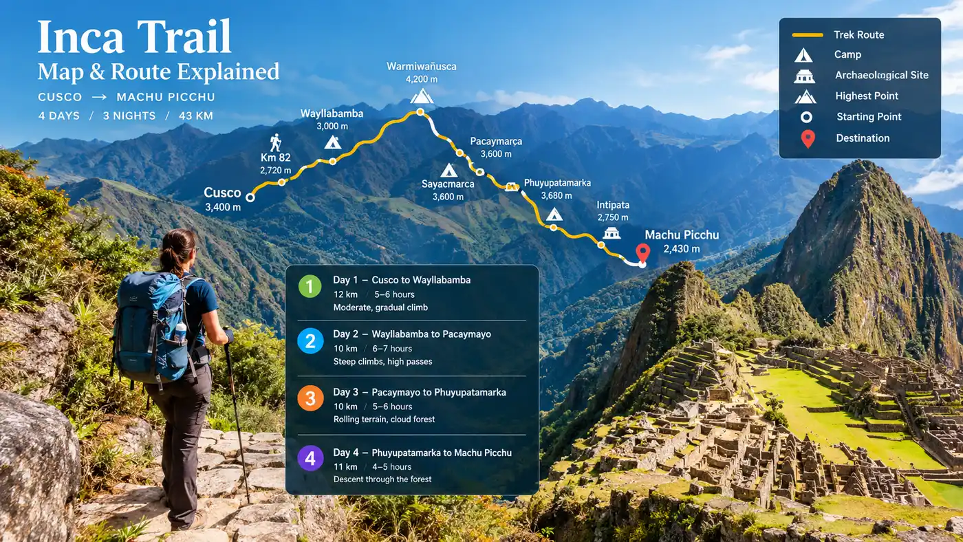
Inca Trail Map Route Explained
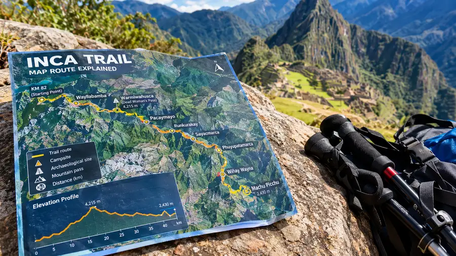
When you unfold a paper inca trail map for the first time, your eyes will probably lock onto the jagged elevation profile along the bottom. It looks like a crosscut saw laid on its side. Four days of hiking compressed into a strip of contour lines can look intimidating, or maybe deceptively straightforward, depending on whether you notice the elevation numbers first or the total distance. The trail is only about 43 kilometers long, yet it crosses high mountain ecosystems, deep river gorges, and wet subtropical forest.
I remember sitting at a café in Ollantaytambo the afternoon before our trek started, tracing my finger over the topographic lines while sipping lukewarm muña tea. Looking back, the two-dimensional paper left out quite a bit. It did not show the relentless slickness of wet granite steps near Sayacmarca, nor did it capture the relief of cresting Dead Woman's Pass after hours of slow trudging. To get the most out of your trek, you need to understand how the map lines translate to boots on the ground.
Book your cusco inca trail experience:
Where Does the Inca Trail Start and End on the Map?
If you trace a map of inca trail topography back to its trailhead, you will end up at Kilometer 82. The official name is Piscacucho, a sleepy settlement right beside the railway tracks connecting Ollantaytambo to Aguas Calientes. Most hikers arrive here in small vans after a 5:00 am departure from Cusco. The elevation at the starting gate sits right around 2,600 meters above sea level. You check in at a government control booth where park rangers inspect your passport and original permit. Once cleared, you step onto a swaying footbridge over the churning, brown waters of the Urubamba River.
From that bridge, the trail heads northwest through dry cactus country. This surprises a lot of people. You might picture dense jungle from the beginning, but the lower Sacred Valley is arid and dusty. Prickly pear cactus grows beside the stone walls, and the peaks overhead look bare. As you gain distance, the trail follows the Cusichaca River canyon, slowly turning south before winding up toward the high Andes.
The journey ends at Inti Punku, the Sun Gate, perched at 2,730 meters. This ancient stone portal frames Machu Picchu below. From the Sun Gate, an easy downhill stroll takes you right onto the agricultural terraces above the citadel ruins. When asking where does the inca trail start and end, people often assume the endpoint is the citadel itself. Technically, the hiking path ends at the guardhouse terraces where hikers mingle with train tourists smelling of fresh shampoo, which feels surreal after four days without a hot shower.
Reading the Classic Inca Trail Route Day by Day
A classic inca trail map peru displays four distinct segments, matching the typical commercial itinerary. Each day delivers a completely different microclimate, gradient, and physical toll on your knees.
The first day acts as a gentle warm-up. You cover roughly 12 kilometers across undulating terrain. The trail passes rural homesteads where local Quechua families sell bottled water and sports drinks from wooden tables. You get sweeping views across the valley floor to the massive ruins of Patallacta, an administrative settlement built into the hillside. Campsites for the first night usually sit at Wayllabamba or Ayapata. Ayapata is higher up at around 3,300 meters, which makes night one colder, but it knocks an hour off the terrible climb waiting the next morning.
Day two on the inca trail route is the test. You leave early, climbing straight up stone staircases through the cloud forest into the alpine tundra. Dead Woman's Pass sits at 4,215 meters. From the bottom of the pass, you can see tiny colorful dots moving slowly along the saddle above you. You reach the top through sheer patience, catch your breath in the freezing wind, and immediately drop down 700 vertical meters into the Pacaymayo Valley on knee-jarring stone steps. Our classic Inca Trail 4 days itinerary breaks down how different guiding outfits pace this grueling climb.
Pro tip: Pack two pairs of hiking pole rubber tips in your daypack; the sharp granite rocks on day two eat through cheap rubber caps, and bare metal spikes are strictly banned on the stone steps.
Day three is long and visually incredible. You climb a second pass at Runkurakay, drop past circular watchtowers, and cross into lush, mossy cloud forest. Stone tunnels carved straight through granite cliffs lead to Sayacmarca and Phuyupatamarca. The day finishes with thousands of descending steps toward Wiñay Wayna. Day four starts around 3:30 am with a quick dash along a flat jungle path to the Sun Gate, just in time for sunrise.
| Trek Day | Route Segment | Distance | Elevation Change | Avg. Hiking Time |
|---|---|---|---|---|
| Day 1 | Km 82 to Ayapata | 14 km | +700 m | 6 hours |
| Day 2 | Ayapata to Chaquicocha | 16 km | +915 m / -715 m | 8 to 9 hours |
| Day 3 | Chaquicocha to Wiñay Wayna | 10 km | -950 m | 5 hours |
| Day 4 | Wiñay Wayna to Machu Picchu | 5 km | -270 m | 2 hours |
Understanding the Inca Trail Elevation Map and High Passes
Looking at an inca trail elevation map helps you understand why distance numbers are meaningless out here. Twelve kilometers on a flat suburban path takes roughly two hours. Twelve kilometers on day two of this route takes almost eight hours of continuous effort. The thin air pulls at your lungs from the moment you pass 3,500 meters.
The profile shows two massive peaks separated by a deep valley. The first hump is Warmiwañusqa, or Dead Woman's Pass. Reaching 4,215 meters, it is the highest point of the trek. You feel every step in your calves. The wind usually howls through the gap between the two peaks, and temperatures can plummet near freezing in minutes if cloud rolls in. Many hikers struggle here with mild altitude sickness, especially if they only spent a single night in Cusco before lacing up their boots.
After dropping to the valley floor, the map climbs right back up to Runkurakay Pass at 3,950 meters. While technically lower than Dead Woman's Pass, your legs are already exhausted from the previous descent, making this second ascent mentally tough. Checking our guide to Inca Trail elevation gain gives you a clearer picture of how these steep shifts affect your pacing.
Downhill sections are equally brutal on the elevation chart. You lose nearly 1,000 meters in a single afternoon dropping into Wiñay Wayna. The ancient Incas did not build ramps; they built steep, irregular steps out of solid stone. Every step down sends shockwaves through your quads and kneecaps. Honestly, my knees complained more on the downhill drops than my lungs did on the climbs.
Book your cusco inca trail experience:
Key Landmarks on the Inca Trail to Machu Picchu Map
The route is not just an endurance hike; it is an open-air museum. The inca trail to machu picchu map connects a network of ancient ceremonial and administrative stations that once supplied the royal estate at the end of the line.
- Patallacta: an expansive terraced complex viewed from high above on day one, used for food production to supply mountain travelers.
- Runkurakay: a semi-circular stone structure perched on the hillside, likely an Incan tambo or rest stop for chasqui messengers.
- Sayacmarca: a cliffside fortress accessed by a narrow stone staircase perched high above the Aobamba Valley.
- Phuyupatamarca: known as the Town in the Clouds, featuring five ceremonial stone baths fed by an intricate irrigation system.
- Wiñay Wayna: perhaps the most stunning ruin before the finish, clinging to a steep mountainside with cascading agricultural terraces.
Phuyupatamarca sits right on a ridge crest. When the morning mist clears, you can look straight down into the Urubamba gorge thousands of feet below. It was built with spiritual intent, aligning with surrounding peaks like Veronica and Salkantay. Spending twenty minutes walking through its baths and stone rooms gives you real appreciation for Incan masonry.
Note: Campsite allocations along the map are assigned strictly by the Peruvian Ministry of Culture when your permit is booked; your guide cannot swap your camp on the trail to make a day shorter or longer.
Wiñay Wayna is the final stop before Machu Picchu. Most groups camp right beside the ruins on night three. The site is named after an orange orchid that blooms along the stone banks. If your legs have any energy left after dinner, walking over to the terraces at dusk while the clouds drift through the valley is magical.
Practical Navigation and Trail Realities
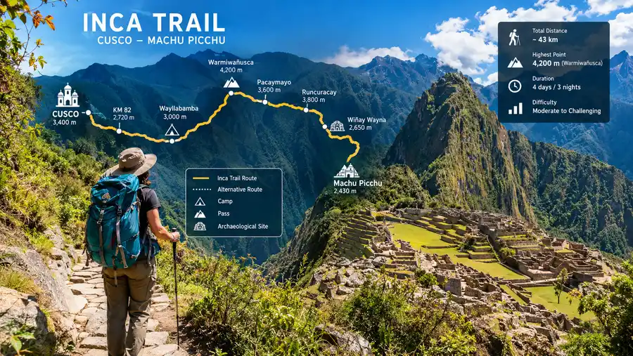
Can you navigate using a map inca trail layout on your own? In practical terms, no. Independent trekking on the classic route was banned by the Peruvian government in 2001. You must hike with an authorized tour agency, licensed guides, and registered porters.
Getting physically lost on the stone trail is nearly impossible anyway. The original Incan highway is bordered by dense vegetation or sheer rock walls for long stretches. There are no unmarked branching junctions or confusing forest forks. However, having good inca trail maps helps you manage mental stamina. Knowing that the next water point is 3 kilometers away or that a steep climb lasts another 400 vertical meters helps you keep your rhythm.
- Steep drops: many sections through the cloud forest run along narrow ridges with unprotected drops on one side.
- Morning queues: the checkpoint out of Wiñay Wayna on the final morning creates a bottleneck where groups wait in the dark.
- Campsite distance: depending on your assigned camps, your second day might end at Pacaymayo or continue an extra three hours to Chaquicocha.
- Changing weather: sunny valleys can turn into sideways hailstorms within thirty minutes as you crest the high ridges.
The maps also will not prepare you for the speed of the porters. While you stop to catch your breath every twenty steps, local porters carrying 20-kilogram loads on their backs will jog lightly past you in rubber sandals, smiling and wishing you a good day. It is humbling to say the least.
Frequently Asked Questions about inca trail map
How many miles is the full Inca Trail route?
The standard classic route covers approximately 26 miles, or 43 kilometers, from the trailhead at Kilometer 82 to the Sun Gate above Machu Picchu.
What is the highest point shown on the elevation profile?
Dead Woman's Pass, known locally as Warmiwañusqa, marks the trail's highest point at 4,215 meters (13,828 feet) above sea level on day two.
Are digital GPS maps useful on the trail?
Digital maps can be fun for tracking your elevation and daily distance, but cell service is non-existent for most of the trek. You will need to download offline maps beforehand.
Quick Reference
- Starting point: Kilometer 82 (Piscacucho) at 2,600m
- Finishing point: Sun Gate (Inti Punku) at 2,730m
- Highest pass: Dead Woman's Pass at 4,215m
- Total route distance: 43 kilometers (26 miles)
- Standard trek duration: 4 days and 3 nights
Book your cusco inca trail experience:
The Bottom Line
Looking at a map of the trail gives you a roadmap for your legs, but the trek itself defies neat lines and elevation graphs. You will remember the cold mountain rain, the smell of burning eucalyptus wood in the valleys, and the sudden moment Machu Picchu reveals itself through the morning fog far more than any contour line. Study the profile to prepare your body, pack your trekking poles, and take the climbs one slow step at a time.
Read more about cusco inca trail.